Blog Post
The Ultimate Guide to Ship Navigation Equipment and Its Role in Seamless Voyages
Posted By: Harsh Bamnolia
Posted On : 30-Mar-2025
The Ultimate Guide to Ship Navigation Equipment and Its Role in Seamless Voyages
Understanding Ship Navigation Equipment
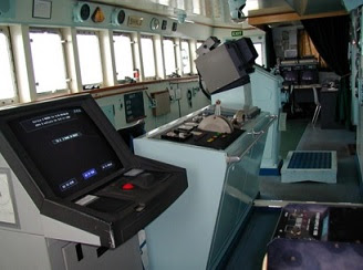
A ship navigation equipment plays a crucial role in ensuring safe, efficient, and seamless voyages across the vast oceans.
From traditional compasses to advanced electronic navigation systems, modern ships rely on a combination of cutting-edge technologies to maneuver through unpredictable waters.
The purpose of ship navigation equipment is to enhance accuracy, improve safety, and optimize routes while complying with international maritime regulations.
In 2025, navigation technology is evolving rapidly, with AI-driven automation, satellite-based communication, and integrated control systems setting new standards in maritime travel.
This guide explores the essential ship navigation equipment, their role in seamless voyages, and how advanced solutions contribute to modern maritime operations.
Essential Ship Navigation Equipment for Seamless Voyages
Modern ship navigation equipment is designed to improve accuracy, safety, and efficiency. Below are some of the most essential ship navigation tools used in maritime travel:
1. GPS and Electronic Chart Display & Information System (ECDIS)
GPS (Global Positioning System) provides real-time location tracking for ships.
ECDIS (Electronic Chart Display and Information System) replaces traditional paper charts with automated route planning and digital mapping.
Together, these systems enhance voyage planning, reduce human errors, and improve navigational accuracy.
2. RADAR (Radio Detection and Ranging)
Used for detecting nearby vessels, land masses, icebergs, and floating obstacles.
Works effectively in low visibility conditions, including fog, rain, and storms.
Prevents collisions and assists in proximity awareness and situational control.
3. AIS (Automatic Identification System)
Helps ships identify and track other vessels in real time.
Displays ship name, position, speed, and course information to avoid accidents.
Works in coordination with RADAR for safer navigation in busy waters.
4. Magnetic and Gyro Compass
Magnetic Compass: Traditional navigation tool that aligns with Earth’s magnetic field.
Gyro Compass: Provides more stable readings unaffected by external magnetic disturbances.
Used as backup systems in case of electronic failures.
5. GMDSS (Global Maritime Distress and Safety System)
A critical part of ship navigation equipment that enables emergency communication.
Allows ships to send distress signals via radio, satellite, and digital systems.
Helps in coordinating search and rescue (SAR) operations efficiently.
6. Echo Sounder (Depth Measurement System)
Measures the depth of water beneath the vessel using sound waves.
Prevents grounding in shallow waters and assists in safe anchoring.
Works in conjunction with sonar systems for underwater mapping.
7. Speed Log and AutoPilot Systems
Speed Log monitors the ship’s speed relative to water or ground.
AutoPilot systems maintain the ship’s course automatically, reducing human fatigue.
Enhances fuel efficiency and reduces navigation errors.
8. Navtex and Meteorological Systems
Navtex receivers provide ships with real-time weather alerts, navigational warnings, and distress messages.
Helps ships avoid rough seas, hurricanes, and extreme weather conditions.
Advanced Ship Navigation Equipment Provided by Marinetech
As a leader in marine navigation solutions, Marinetech Safety & Shipping Corporation supplies state-of-the-art ship navigation equipment for safe and efficient voyages.
1. Cutting-Edge GPS and ECDIS Systems
High-precision GPS receivers for accurate global positioning.
ECDIS solutions with automated charting and AI-powered route optimization.
2. AIS, RADAR, and Collision Prevention Systems
AIS transponders for real-time vessel tracking.
Marine RADAR systems for hazard detection and proximity alerts.
3. GMDSS Emergency Communication Systems
VHF, UHF, MF/HF radio systems for ship-to-ship and ship-to-shore communication.
AIS SART (Search and Rescue Transponder) and EPIRB (Emergency Position Indicating Radio Beacon).
4. Echo Sounders and Depth-Sensing Equipment
Advanced sonar systems for depth measurement and seabed mapping.
Highly accurate speed logs for monitoring vessel movement.
5. AutoPilot and Fuel-Efficient Navigation Systems
Smart AutoPilot software for energy-efficient voyages.
AI-integrated tools to optimize route planning and fuel consumption.
Conclusion
A ship's navigation equipment is fundamental to ensuring safe, efficient, and regulatory-compliant voyages.
From traditional compasses to AI-driven automation, modern navigation tools have transformed the maritime industry, reducing risks and enhancing operational accuracy.
By investing in advanced ship navigation equipment, maritime professionals can optimize fuel efficiency, minimize human errors, and improve voyage planning.
At Marinetech Safety & Shipping Corporation, we offer a comprehensive range of ship navigation systems designed for maximum precision, security, and efficiency.
To explore our latest ship navigation equipment, visit https://marinetechss.com/services/electronic-and-navigation-communication-service today!